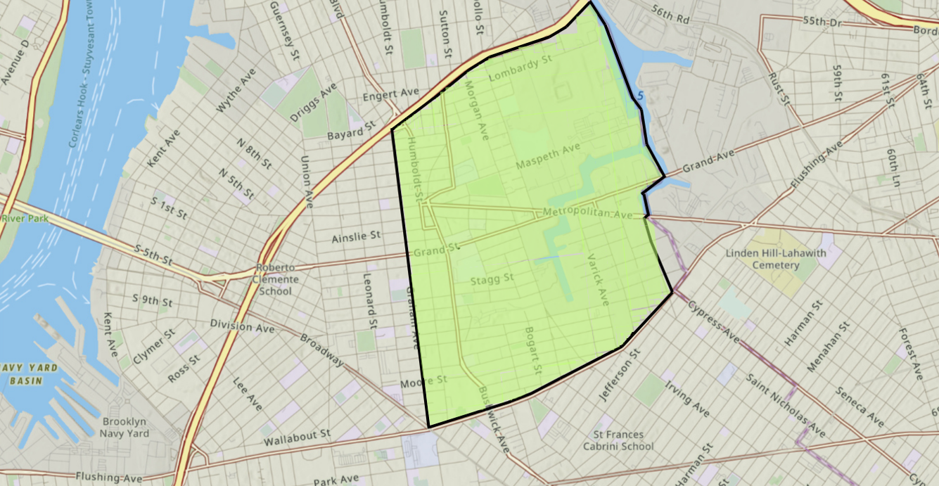
It’s always been of great interest to me what people call this area. Some call it Bushwick, some call it Greenpoint, and some call it East Williamsburg. To me, after nearly 15 years and over a third of my life in the neighborhood, I refer to it as eastern Williamsburg. Few people do this, but there’s a rationale, rooted in history and practicality, that led me to this distinction.
Sometime after 2024, Google Maps changed the borders of multiple NYC neighborhoods, I imagined based on data The New York Times published in 2023 mapping out the city’s various neighborhoods. These changes impacted the borders of the neighborhoods of Bushwick and “East” Williamsburg. When I originally wrote this piece on r/EastWilliamsburg, the northern border of Bushwick on Google Maps was Flushing Avenue, and I make many references to that dividing line. As I did then, I still believe this to be the case as of 2026. (For a simple breakdown of my perspective on the borders of Williamsburg and northern Bushwick, please reference the Addendum at the end of this article.)
Bushwick Beginnings
It should be noted that, due to a fire and poor record-keeping during the administrative transition that accompanied the annexation of Bushwick and Williamsburg by the City of Brooklyn in the 1850s, many official records from this period have been lost. From the mid-1600s to the early 1800s, historic Boswijck (Bushwick) included the present-day Brooklyn neighborhoods of Bushwick, Greenpoint, and Williamsburg.
By the late 1700s and early 1800s, much of what had been Lenape––specifically Canarsie––settlements had been largely eliminated for over a century and displaced by American and European-settler colonial developments.
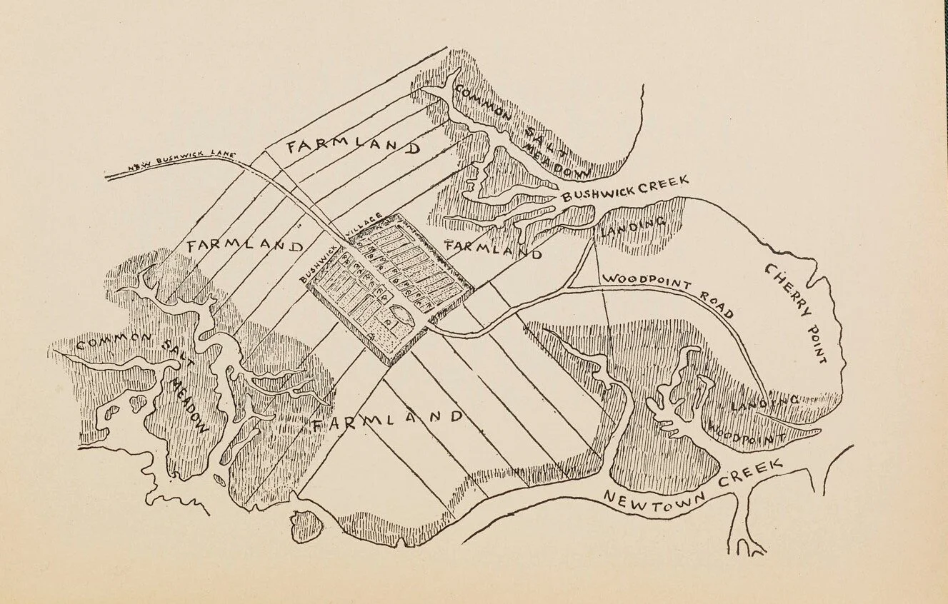
Boswijck, meaning “village in the woods” in Dutch, was surrounded by fields and farms, making hard borders difficult to come by. The land east of modern-day Bushwick Avenue to Newtown Creek was largely undeveloped aside from some scattered local farm plots. This area was also considered to be part of the Town of Bushwick.
Not long after the American Revolution, Williamsburg became a focal point of intense land development activity. In 1792, Richard M. Woodhull, a New York City merchant and Woodhull Hospital’s namesake, bought considerable tracts of land, hoping to attract settlers from across the East River. In 1802, Woodhull hired Colonel Jonathan Williams, grand-nephew of Benjamin Franklin, to survey the land and lay out lots for homes. Pleased with the work Williams had done, he named the area “Williamsburgh” in his honor.
Two ferry terminals at the shores of the East River—one operated at Metropolitan Avenue (then North 2nd St) by Woodhull and another at Grand Street by Thomas Morrell—were key to the growth Williamsburg would soon see.
The Morrell family had long been prominent in Brooklyn, and in 1804, Morrell, like Woodhull, had the land surveyed and divided into lots. Morrell cut a road through the middle of the old farm, which he called Grand Street, and called the site of the ferry Morrell Point. Grand Street soon became one of the main business streets of Williamsburgh. A stone wall at the southern edge of his property formed the boundary between Woodhull’s Williamsburgh and Morrell’s “Yorkton,” which took the name Division Avenue.
Morrell and Woodhull’s ferry services were crude and difficult to operate. When passengers wanted to cross the East River to New York on Morrell’s ferry, they would blow a horn that was kept at the landing to call Morrell from his farm work. Woodhull’s service was a simple rowboat. After both men suffered considerable financial loss competing against one another, the two rivals entered into a partnership and established the Williamsburgh Ferry.

1943 Brooklyn Profiles – Market Analysis – 1 
1943 Brooklyn Profiles – Market Analysis – 2 
1943 Brooklyn Profiles – Market Analysis – 3 
1943 Brooklyn Profiles – Market Analysis – 4 
1943 Brooklyn Profiles – Market Analysis – 5 
1943 Brooklyn Profiles – Market Analysis – 6 
1943 Brooklyn Profiles – Market Analysis – 7 
1943 Brooklyn Profiles – Market Analysis – 8
Simultaneously, Newtown Creek was a convenient connecting waterway for shipping to and from the East River and out into New York Harbor, and industry and manufacturing began to grow in the area in the early 1800s.
As the industry grew, a more distinct identity and population of Williamsburgh began to emerge. In 1827, it was incorporated as the Village of Williamsburgh within the Town of Bushwick. Over time, the Conselyea, Devoe, Ainslie, Meserole, McKibbin, Lorimer, and Graham farm and landowner families and others ultimately peeled off from the Town of Bushwick to align with the growing independent community of Williamsburgh. Ultimately, Williamsburgh separated from Bushwick entirely to become the neighboring incorporated Town of Williamsburgh in 1840.
The ferry connections to Manhattan that dotted the banks of Williamsburgh’s East River shoreline were central to its early identity and a key factor in the town’s rapid growth and heavy development that led to its eventual, albeit brief, stint as its own independent city from 1851 to 1855 before being annexed by the City of Brooklyn in 1855. At the time of annexation, Williamsburgh’s population was nearly ten times the size of Bushwick’s.
As Williamsburgh expanded geographically, the terms north, south, Dutchtown, Third District, east, west, and waterfront came into use to describe the different sectors of Williamsburgh. The “central”/core area has typically been around the commercial district around Bedford Avenue, as it was a convenient connection to the commerce and jobs brought into the area by the many factories that lined the East River waterfront starting in the 1800s. East of Union Avenue, toward modern Bushwick Avenue, development began later, but it has been densely populated for at least 150 years.
Eastern Williamsburg: It Is What It Isn’t
To help sort out what this area is, we first have to look at what it isn’t. As mentioned above, nearly all of north Brooklyn was once Bushwick, but as these areas developed, they split away.
This demonstrates two important factors: a.) Bushwick had a much firmer identity and more prominent historical relevance due to its older history, and b.) because of this firmer identity, divergence from it would cause new breakoff communities to form. These concepts set the stage for how Williamsburg and Greenpoint came to be, and explain how Bushwick was reduced to its core districts in the 20th century.


One constant in the eastern Williamsburg area has been a lower population density relative to the surrounding communities, particularly between Grand Street, Flushing Avenue, and Newtown Creek, especially around the present-day Morgan Avenue subway station.
Today, if you walk east beyond Bushwick Avenue on Grand or Metropolitan, the community will shift from residential and commercial to industrial and manufacturing. As described in this succinct video from real estate investor Eric Brody, the area is still zoned as “M” (manufacturing), which limits land usage purposes.
This trend continues further east into Maspeth and past the Rust Street railway junction, where industry and manufacturing remain prevalent, though far from the levels seen in the 1940s and earlier.
Archival photos from the 1940s show this area’s low density and manufacturing-heavy industrial character—the exception to this being the area south of Johnson Ave between Bushwick Ave and Varick Ave. The area was bustling with industry, from door-frame manufacturers to gas works to auto shops, and sprawled to nearly the same size as the original Williamsburg development (from the river to Union Ave). A great deal of this industrial development pushed out the area’s residents.
Even then, few people wanted to be surrounded by the din, grind, and constant noise and air pollution that came along with the many factories, dyers, and scrap iron yards. This led to the undesirable tract of land being predominantly populated by newly arrived Western and Central European immigrants. These new residents became the working class and working poor of the neighborhood, shuffling into the local mills and factories by day, and residing in the low-income tenement buildings made famous in Betty Smith’s semi-autobiographical 1943 novel A Tree Grows in Brooklyn.


The main reason I focus on the area’s residential density and industrial zoning is to make my case that, because this area was less developed, it was often casually clumped in with other nearby neighborhoods that overshadowed it in importance, regardless of historical and jurisdictional accuracy.
Additionally, unaware of the area’s history, new residents 100+ years ago may have gravitated toward existing neighboring communities for cultural or ethnic familiarity. This means differences could emerge among neighbors within the same community, each aligned with different neighborhoods (Bushwick, Greenpoint, or Williamsburg), with no governing body to resolve minor neighborhood boundary disputes—something that still happens all over the city today.
All the while, eastern Williamsburg was developing its own industrial-centered sub-community, breaking off from Bushwick because of what it isn’t.
As of this 2026 publication, despite over 30 years of heavy development, this area remains underpopulated relative to the surrounding communities due to its zoning and land-use history. Mix in modern developments, deindustrialization, few surviving residents with family ties to the 1800s and early 1900s, and an influx of new residents who don’t know the area’s history, and you’re left with a distorted vision of the past.
And fair enough—it can be challenging to look at an industrial no man’s land, now or 80-100 years ago, and try to determine where you are. However, there are several landmarks that can help you orient yourself.
The 14th St-Eastern District Line
In 1924, the “14th St Line” (now the L train) was completed under the official title of the 14th Street-Eastern District Line, which ended at Montrose Avenue. The “Eastern District” referred to here is the eastern district of Williamsburg.
At this time, trains used to physically exit Montrose Avenue station and be deposited into the old LIRR Bushwick Branch rail yard, currently behind 258 to 270 Meserole Street.
Because the city initially failed to approve the joining of the subway line between Montrose Avenue and East New York, the 14th Street-Eastern Line was isolated from the rest of the system until it was extended to Morgan Ave and beyond in 1928 and ultimately connected to the Canarsie Line at Broadway Junction, making the full length of the L line we know today.
Looking at the L train’s route and station planning shows where major population centers were, and still generally are. The lack of subway stations in this area suggests lower demand than in the rest of the neighborhood, since there was not enough ridership to support service. Everything east of Montrose station and north of Morgan station was essentially bypassed, even though the area had freight, LIRR, and some trolley service at the time.
For a glimpse into the industrial past of eastern Williamsburg, you can still watch small freight trains run once or twice a day on these existing lines, crossing Morgan Avenue just south of Meserole Street and heading east toward 99 Scott Avenue.
East Williamsburg In-Place Industrial Park
The existence of this designation should be a big nail in the coffin for most people, yet it is frequently overlooked, despite the faded signage that demarcates it.
Named and formed long before the early 2000s hipsters started showing up, the East Williamsburg “valley” industrial park, as referenced in a 1984 NY Times article, attempted to refresh the industrial area’s image to drive new investment at a time when the city was recovering financially. Various industrial East Williamsburg branding has been used since the 1960s as well.
St. Catherine Hospital
St. Catherine is emblematic of North Brooklyn’s inability to save historic buildings. The fact that it was demolished is a tragedy. Even if it were converted into yuppie apartments, I’d still be happy to look at it. My complaints aside, this historic hospital and nearby Jennings Hall have always been considered part of Williamsburg despite being east of Bushwick Avenue.
Eastern District High School
While this school was originally west of its current location (north of Marcy), it was moved in the mid-90s to the site of the old St. Catherine Hospital but kept its original name. It is east of Bushwick Avenue, which some would say makes it “Bushwick,” but multiple school programs refer to it as being in Williamsburg or East Williamsburg.
Appearances in Publications of Record
You’ll find a number of records if you search for prominent street names in this area (Varick, Morgan, Gardner, etc.), though these areas are commonly referred to as “Brooklyn” or “North Brooklyn” and not specific neighborhoods. Even if they mention another neighborhood in the same article (ex. Canarsie, Flatbush), they most often do not claim this region for any specific area, signaling its unclaimed status.
“East Williamsburg” appears by name in newspapers as early as the mid-1850s, with some mentions, such as this 1869 land purchase and an 1887 report about a fireworks factory explosion.
Across articles from 1980 to 2000, the name appears more frequently. First, in a 1985 story in The New York Times on the Pfizer building, which is technically in Bed-Stuy. Even the parts they reference are all to the east of Union/Marcy Aves, illustrating how Union Ave once served as Williamsburg’s dividing line. If you take the NYT’s 1980s definition of the area, “East Williamsburg” was the community east of Union—the old Eastern District of Williamsburg. The next year, the Times referred to “Prospects for Williamsburg’s industrial area, known as East Williamsburg.” A decade later, East Williamsburg received its own neighborhood report.


Causes of Confusion
State of Constant Change
Even during its nascent growth in the first half of the 1800s, historic Williamsburgh was already being split into distinct districts, with names that have changed over time as the steady flow of new residents reshaped the area.
Many of Williamsburg’s sub-neighborhoods, communities, and street names would be unfamiliar to us, and have led to a consistent part of history being erased or overwritten. Even many of the street names we’re familiar with today were only put in place in the 1910s and 1920s, as strong anti-German sentiment forced many of the German-inspired street names to change in the wake of World War I.
The Ward System
Some complications arose due to the old and chaotic Brooklyn ward system, which is equivalent to today’s electoral districts. Additionally, these wards were gerrymandered and changed multiple times as Brooklyn grew, as evidenced by the differences between the ward maps and descriptions from 1855 and 1866.
Electoral politics in this era were a mess, with election boundaries often changed due to rampant corruption in the City of Brooklyn and, ultimately, in the consolidated City of New York. This ward system first appeared in the NYTimes in 1853, discussing the consolidation of Brooklyn, Williamsburg, and Bushwick. “Bushwick shall be entitled to two wards, making the north road running through Bushwick the division of the two wards. Williamsburg to be entitled to four wards, the lines of division to be determined hereafter.”
East Williamsburg of Newtown and Queens
Another complicating factor is that there was also an “East Williamsburg(h)” in the 1800s and early 1900s in what is now Ridgewood and Maspeth, back when this area was also referred to as Newtown, Long Island. So when people say East Williamsburg doesn’t exist, that doesn’t make sense in more ways than one.
Multiple articles from the late 19th century, including deaths in 1870 and 1892, and an 1877 murder, attest to East Williamsburg(h)’s recognition in written media. One church in Ridgewood was a historic hub of East Williamsburg, Queens.
The existence of this neighborhood in Queens may explain why “east Williamsburgh*” in Williamsburg*h (Brooklyn) and “East Williamsburg” in Newtown, Queens/Long Island, had different spellings and why the Brooklyn one ultimately dropped the “h” later in history when East Williamsburg, Ridgewood, Queens, ultimately disappeared and fell out of use.
Around Cooper Park
The blocks surrounding Cooper Park have held multiple names because of the glue factory that once occupied its grounds. Some historical documents refer to it as ‘Newtown’ or ‘on/at Newtown Creek,’ and others refer to it as ‘East Williamsburg(h)’, Queens, or Long Island.
Obscuring the matter further is that the hospital, which was built just north of the park, was called Greenpoint Hospital. It remains a borderland zone, especially after the BQE construction (1930s-60s), which more firmly divided the neighborhoods.
If any area is disputed, it should be just around and north of Cooper Park, south of the BQE, and east of Kingsland/Woodpoint. The architecture feels like a hybrid of the two neighborhoods. In archival photos, you see ‘Greenpoint’ on industrial buildings, such as on the corner of Sharon/Morgan and Maspeth/Morgan.
Newtown Creek
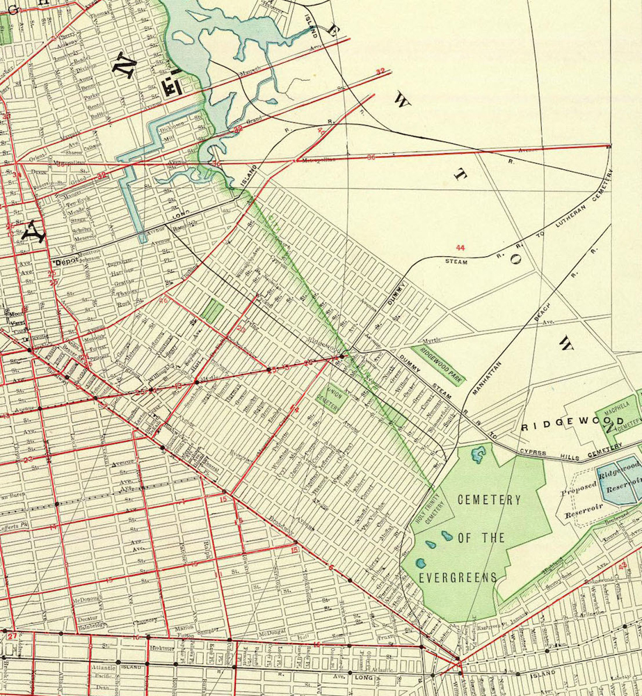
Newtown Creek as we know it today was not the Newtown Creek of centuries ago (called the Nassau River). It was full of meandering streams and small islands as seen in this 1891 map. For this reason, major residential settlements developed more slowly than in dryland areas due to flooding in the lowlands and to the water’s already heavy pollution.


Bushwick vs East Williamsburg Naming Controversies
This piece of recent local history has been lost on people, especially those who arrived after 2010. The issue was that, in the early 2000s, new residents of Bushwick south of Flushing Ave (which has always been 100% Bushwick) began referring to parts of it as “East Williamsburg”. You can see this in a 2004 NYTimes article about what is now the Opera House Lofts on Arion Place.
To further complicate things, there was a Ridgewood section of Bushwick until 1980. Per a 1979 NYTimes article: “In fact, Ridgewood had the same ZIP code as Bushwick until the 1970s, but the contagion of arson, drugs and blight that consumed large areas of Bushwick and East New York in the 1970s alarmed some residents on the Queens side.” This led Geraldine Ferraro to campaign for a new ZIP code for her then-Congressional seat. This led to Ridgewood and Glendale gaining a Queens ZIP code (11385), while Bushwick obtained the Brooklyn ZIP code 11237 in January 1980.
Similar neighborhood movements occurred in Williamsburg after the 1977 NYC blackout, which, for many at the time, made the name Bushwick synonymous with crime, driving residents to call their area Williamsburg rather than Bushwick.
Economics and Change
NYC is, and always has been, constantly changing. This has been especially true in poorer or immigrant-heavy areas. Populations have always changed more quickly in these areas as people exit the working class or poverty for the middle class, especially when home ownership is lower, and local landlords offer only a limited standard of living.
Williamsburg has been German, Irish, Italian, Eastern European, Puerto Rican, and Dominican, and will change again and again as the city evolves. History is lost or forgotten every time this happens.
Official Neighborhoods
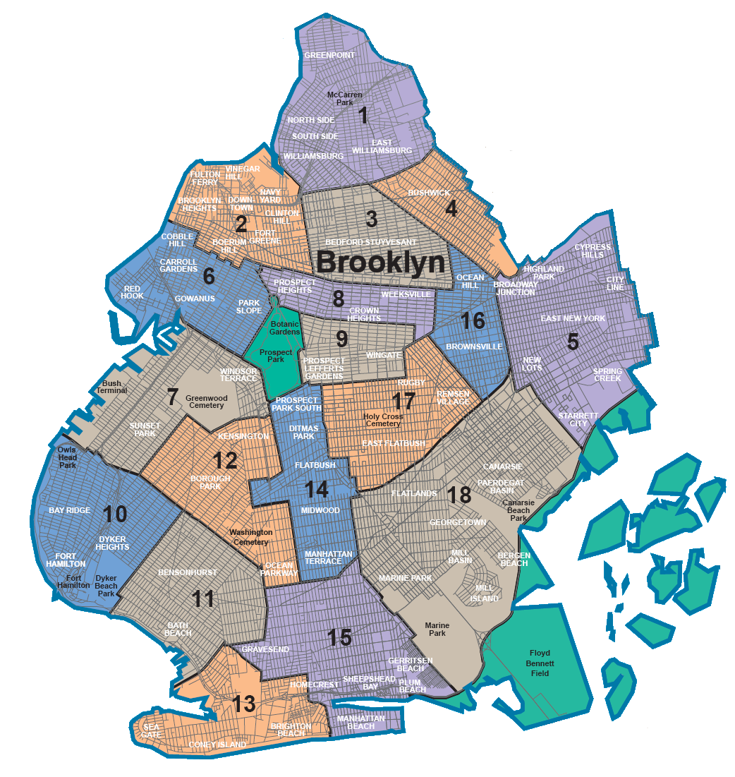
We will never get a 100% definitive government-backed answer to this question because there are no government-defined neighborhoods in NYC. Community boards are the closest we get.
Look at what was once the Five Points neighborhood. The area has been entirely wiped away, and even most of the street names are different. The naming of NYC’s neighborhoods is constantly changing. The Lower East Side, Little Italy, Chinatown, “South Brooklyn” (now 5+ neighborhoods), etc, have all changed or shifted in the last 100 years.


The Follies of Good Intentions
It is worth mentioning that, years later, and into the present day, the Bushwick-East Williamsburg border saga has evolved into a symbol of the broader gentrification struggle in North Brooklyn, and of the friction between the yuppie-hipster brand of Williamsburg/East Williamsburg and the lower- to middle-class communities of Bushwick, who were being gentrified.
In an attempt to remedy the inequities and cultural erasure that accompanied the gentrification of North Brooklyn that began in the 1980s, many newcomers faced the implication that they were part of the problem. For some, rejecting the term ‘East Williamsburg’ became a low-hanging fruit to separate themselves as the “righteous” new arrivals from the ignorant masses who were the “real problem.”
Ironically, this has united two otherwise opposed camps: gentrifiers eager to distance themselves from the label, and locals who reject the ‘East Williamsburg’ label precisely because of its association with gentrifiers. The result was a chorus of ‘there’s no such thing as East Williamsburg,’ ‘real estate agents made it up,’ or ‘it’s all just Bushwick.’
While not without kernels of truth, this overcorrection carries lasting implications, as it erases more than a century’s worth of rich, complex, and unifying history of the working poor and middle class, who have a strong and lasting connection to the mid- and late-20th-century residents of eastern Williamsburg.

The eastern part of Williamsburg, or “East Williamsburg,” has always been a bit of a misfit. Residents of Greenpoint, Bushwick, Williamsburg, and even Queens have all claimed part of it at different times, but it’s never fully absorbed by any of them. But, time and time again, when it needs a home, it tends to find it in Williamsburg.
While it was surely part of old Bushwick for much of its existence, times changed, and it, like Greenpoint and western Williamsburg before it, became its own territory. While one could argue that it was Bushwick, the same logic applies to Williamsburg and Greenpoint, which also share an ancestral homeland there. In the early 1800s, after the Village of Williamsburgh formed, people might’ve said, “Williamsburgh is Bushwick,” too.
Nonetheless, from the consolidation of Brooklyn to the wards of Brooklyn to the consolidation of NYC to the “EWIPIP” to the subway, the historical evidence points to east/eastern Williamsburg being part of Williamsburg from the mid to late 1800s onward, despite the slower formation of its identity.
The denial of East Williamsburg as a real place was never purely semantic. It is an overcorrection that, whatever its intentions, bulldozes the working-class history that has defined the area but has been difficult to maintain during periods of underrepresentation and intense change.
But in a city like NYC, the challenge is that these changes never stop. In this town, things come and go, mini-civilizations exist, and communities flourish for decades and disappear as if they were never there. Through change and time, it’s wiped away, and someone starts fresh all over again, leaving people unaware of what was there before. But while New York has always had this Etch-A-Sketch quality to its urban development and history, one cannot simply mend the past to fix the future.
Dylan Teggart is a drummer, writer, and a long-time resident of Williamsburg. An alumnus of New York University with a focus in political science and history, he has a deep love and appreciation for the history of New York City, particularly that of north Brooklyn. You can find him on Instagram.
Photos by Andrew Karpan. Archival photos courtesy NYC Department of Records as organized by Julian Boilen. Many thanks to Geoffrey Cobb for additional sourcing and guidance.
Addendum: The Borders of Williamsburg
Based on the evidence outlined above, I define Williamsburg’s neighborhood borders as:
- Western border: shores of the East River
- Eastern border: Newtown Creek, Onderdonk Avenue/Onderdonk house/Seneca Ave
- Southern border: northside of Flushing Avenue between Onderdonk house and Kent Ave/BQE/Brooklyn Navy Yard
- Northern border: Greenpoint neighborhood, loosely based on historic Bushwick Inlet/Bushwick Creek, McCarren Park, and the BQE/Meeker as markers, depending on where you are
Within those borders, there are sub-communities whose borders overlap. It is too difficult to define some of these by street, and it depends on when one looks at Williamsburg’s history, given that it is already made up of multiple sub-communities: Bedford area, northside, southside/Los Sures, east, South/Hasidic Williamsburg, the Italian area around Graham/Lorimer, etc. Each has its own unique flavors.
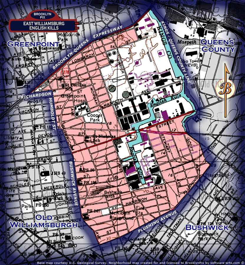
“Eastern Williamsburg” specifically is roughly Graham Avenue eastward to where it meets other borders (Onderdonk House for Queens and Flushing for Bushwick). Some would claim that eastern Williamsburg begins east of Bushwick Avenue, as there are/were distinct architectural and community trends on certain sides of Graham and/or Bushwick, either south or north of Grand. I do not take issue with that, and both interpretations can be correct. That being said, it is just a district and/or sub-neighborhood/community within Williamsburg. Within that is the East Williamsburg In-Place Industrial Park, which follows the border seen here, here (shaded in orange), and here (2005 NYTimes).
Additional Sources & Further Reading:
- Smith, Betty. A Tree Grows in Brooklyn. New York: Harper & Brothers, 1943.
- Cobb, Geoffrey. The Rise and Fall of the Sugar King.
- Cobb, Geoffrey. Williamsburg Transformed: A History of Williamsburg, Brooklyn, 1903 to 1945.
- Cobb, Geoffrey. Greenpoint: Brooklyn’s Forgotten Past.
- Shorto, Russell. The Island at the Center of the World. New York: Doubleday, 2004.
- Merlis, Brian, and Riccardo Gomes. Brooklyn’s Bushwick and East Williamsburgh Communities.
- Echeverría, Diego, dir. Living Los Sures. 1984.
- Noschese, Christine, dir. Metropolitan Avenue. 1985.
- Ortega, Amanda. “The Disputed Neighborhood: Gentrification of ‘East Williamsburg’ and Identity in the Shared Space.” Hofstra Papers in Anthropology 5 (2010).
- “Bushwick, Brooklyn.” The Neighborhoods (Substack).
- History of Most Holy Trinity-St Mary Church. https://www.trinity-stmary.org/our-historic-church
- Archaeological & Historical Sensitivity Evaluation – The Williamsburgh Houses Community Center. Prepared for NYCHA by Greenhouse Consultants Inc., 1995.




Leave a Reply